
Exploring the association between neighbourhood streetscape vegetation and subjective well-being
Title:Exploring the association between neighbourhood streetscape vegetation and subjective well-being in a high-density built environment: Evidence f


Title:Exploring the association between neighbourhood streetscape vegetation and subjective well-being in a high-density built environment: Evidence f
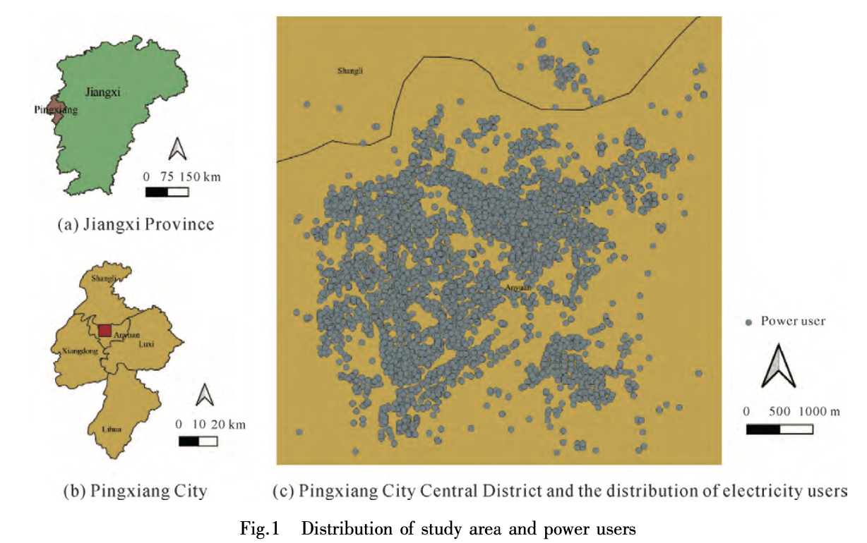
Title:Estimating the spatial variation of electricity consumputionAbstractEffective detection of abnormal electricity users and analysis of the spatia
Title:Assessing myocardial infarction severity from the urban environment perspective in Wuhan, ChinaHighlightsRFA-SHAP far outperforms other models f
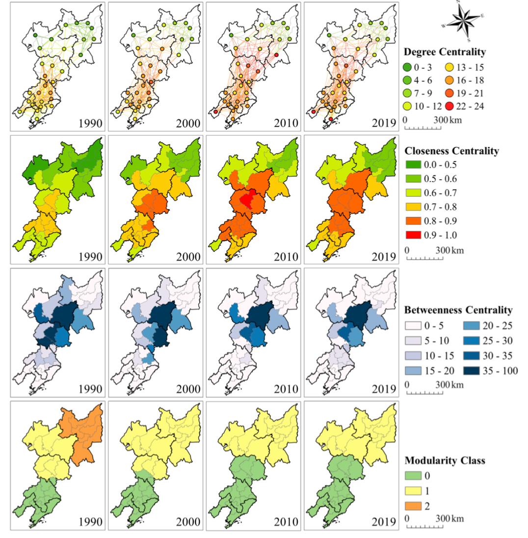
Title:Spatial-Temporal Patterns of Network Structure of Human Settlements Competitiveness in Resource-Based Urban AgglomerationsAbstractResource-based

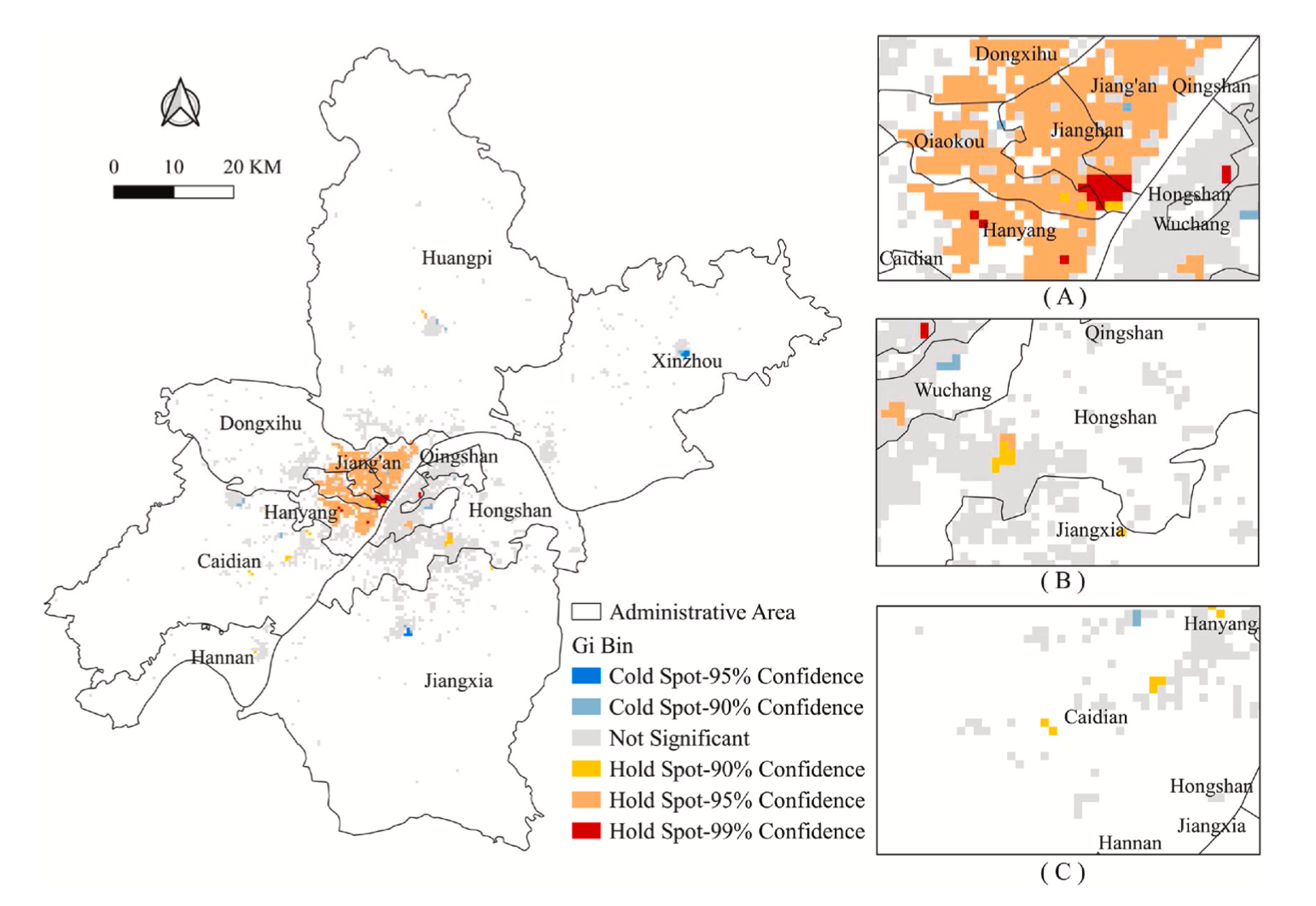
More visible greenspace, stronger heart? Evidence from ischaemic heart disease emergency department visits by middle-aged and older adults in Hubei, C
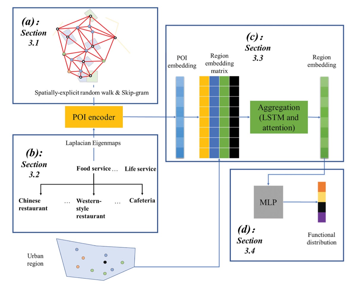
We present a novel approach for estimating the proportional distributions of function types (i.e. functional distributions) in an urban area through learning semantics preserved embeddings of points-of-interest (POIs). Specifically, we represent POIs as low-dimensional vectors to capture (1) the spatial co-occurrence patterns of POIs and (2) the semantics conveyed by the POI hierarchical categories (i.e. categorical semantics). The proposed approach utilizes spatially explicit random walks in a POI network to learn spatial co-occurrence patterns, and a manifold learning algorithm to capture categorical semantics. The learned POI vector embeddings are then aggregated to generate regional embeddings with long short-term memory (LSTM) and attention mechanisms, to take account of the different levels of importance among the POIs in a region. Finally, a multilayer perceptron (MLP) maps regional embeddings to functional distributions. A case study in Xiamen Island, China implements and evaluates the proposed approach. The results indicate that our approach outperforms several competitive baseline models in all evaluation measures, and yields a relatively high consistency between the estimation and ground truth. In addition, a comprehensive error analysis unveils several intrinsic limitations of POI data for this task, e.g. ambiguous linkage between POIs and functions.

Full Title:Associations between the streetscape built environment and walking to school among primary schoolchildren in Beijing, ChinaHighlightsStreet
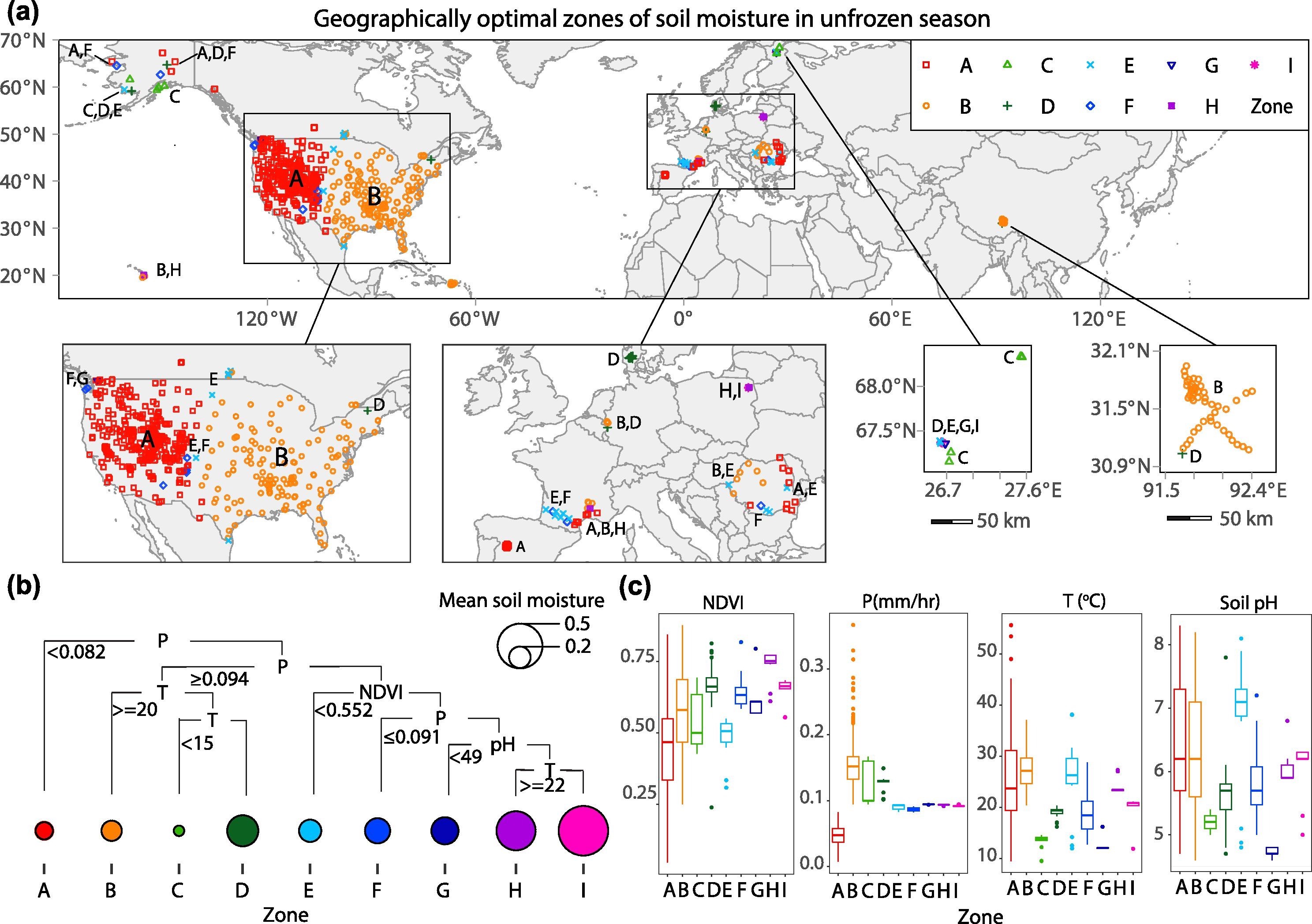
Soil moisture is a fundamental ecological component for climate and hydrological studies. However, the distribution patterns of soil moisture are spatially heterogenous and influenced by multiple environmental factors. The knowledge is still limited in assessing the large-scale spatial heterogeneity of soil moisture in in situ data modelling, in situ network design, spatial down-scaling, and remote sensing-based soil moisture retrieval. Heterogeneity models are effective in characterizing spatial disparities, but they are not capable of examining the maximum regional disparities. To address this bottleneck, the authors of this study developed a geographically optimal zones-based heterogeneity (GOZH) model. By progressively optimizing geographical zones of soil moisture and quantifying the heterogeneity among zones, GOZH may help identify individual and interactive determinants of soil moisture across a large study area. It was applied to identify spatial determinants of in situ soil moisture data collected at 653 monitoring stations in the Northern Hemisphere in unfrozen and frozen seasons from April 2015 to December 2017, with only thawed data considered in both seasons. Correspondingly, a series of variables were derived from Google Earth Engine (GEE) remote sensing data. The results demonstrated the significant regional disparities of soil moisture, and the combinations of determinants are critically different among geographical zones and between unfrozen and frozen seasons. At a global scale, the combinations of determinants can explain about 48% of the spatial pattern of soil moisture. Spatial heterogeneity of soil moisture in frozen seasons is much more complex than that in unfrozen seasons regarding geographical zones and explanatory variables. The variability of soil moisture during unfrozen seasons can be more explainable than that during frozen seasons, which was a convincing evidence for previous studies that soil moisture predictions were mostly performed during unfrozen seasons. Primary variables that determine spatial patterns of soil moisture are changed from climate variables during the unfrozen season to geographical variables during the frozen season. Results show that GOZH model can effectively explore spatial determinants of soil moisture through avoiding the underestimation of individual variables, overestimation of multiple variables, and finely divide zones. The research findings from this study provide an in-depth understanding of the spatial heterogeneity of soil moisture and can be implemented in more effective in situ sampling network design, spatial down-scaling of soil moisture, and accurate inversion of surface parameters from the satellite data of soil moisture.

标题:耦合FLUS和Markov的快速发展城市土地利用空间格局模拟方法Title:A Coupled FLUS and Markov Approach to Simulate the Spatial Pattern of Land Use in Rapidly Developing Cities摘要
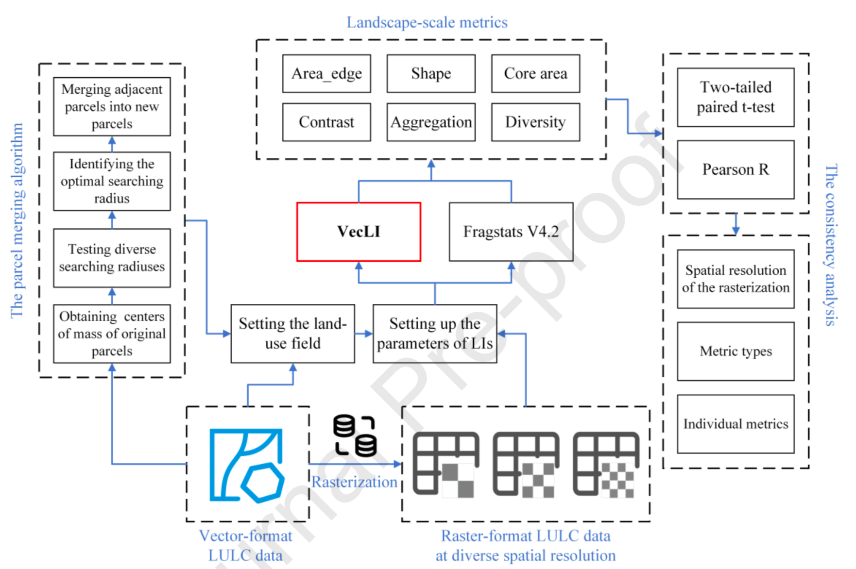
HighlightsA new unifying computational framework for vector-based landscape indices is proposed.74.7% of the VecLI metrics are significantly different
UrbanComp
![]()
![]()
![]()