关于延期举办SpatialDI 2022的通知
关于延期举办SpatialDI 2022的通知 致尊敬的各位参会代表: 近期全国多地出现新冠疫情本土确诊病例,诸多省市(区)陆续出台了最新的疫情防控政策和严格的旅行禁令。为切实保障参会代表人身安全,配合武汉相关防疫部门贯彻落实疫情防控工作部署,经大会组委会和分会主席团审慎共同研究决定,将原定于2022年4月14-16日在武汉举办的“第三届中国空间数据智能学术会议(SpatialDI 2022)” ,延期至2022年6月8-10日举行,相关参会形式和内容将另行通知。 已经完成注册缴费的代表,请您保留好注册及缴费信息,相关信息对延期后会议依然有效。组委会将按照相关规定和财务管理流程妥善处理相关变更事宜,因会议延期给参会代表带来不便,我们深表歉意,敬请谅解! 我们将充分做好本次大会延期召开的各项工作,期待在疫情得到有效控制之后,各位专家、学者继续支持本次会议的举办。 会务组联系人: 范明 15927333030 李应争 13349838503 SpatialDI 2022会务组 2022年4月6日
Estimating urban functional distributions with semantics preserved POI embedding
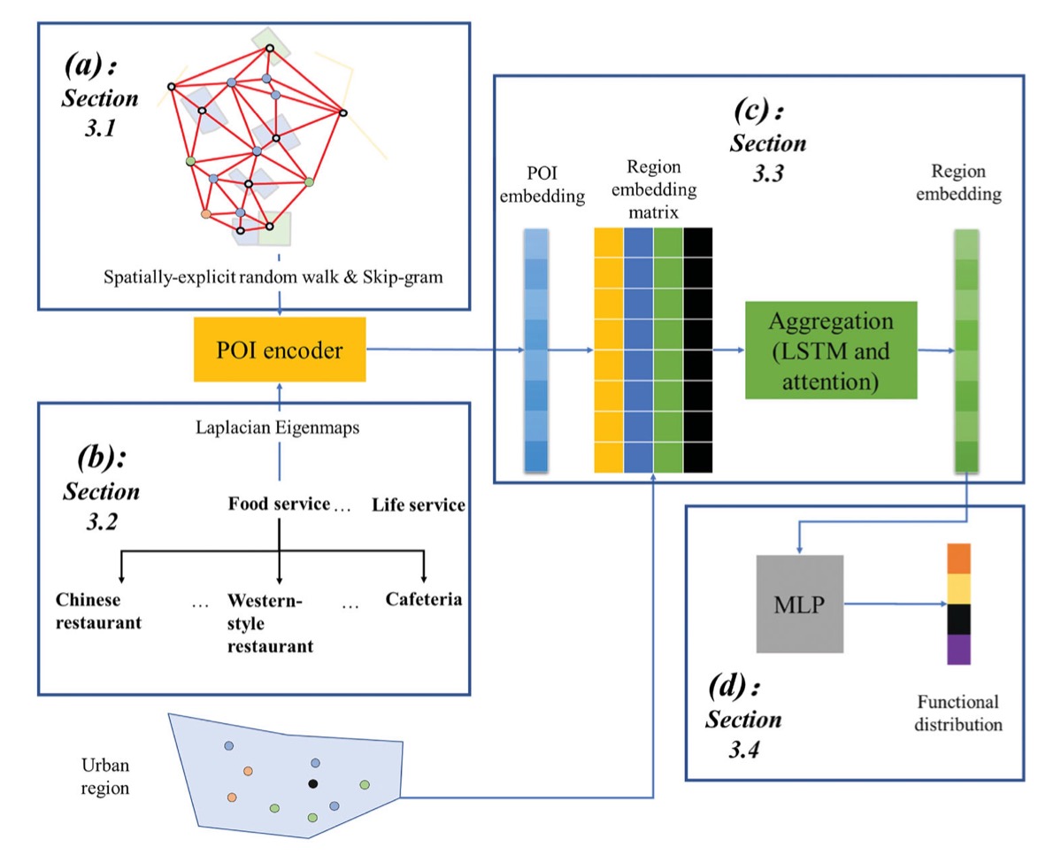
We present a novel approach for estimating the proportional distributions of function types (i.e. functional distributions) in an urban area through learning semantics preserved embeddings of points-of-interest (POIs). Specifically, we represent POIs as low-dimensional vectors to capture (1) the spatial co-occurrence patterns of POIs and (2) the semantics conveyed by the POI hierarchical categories (i.e. categorical semantics). The proposed approach utilizes spatially explicit random walks in a POI network to learn spatial co-occurrence patterns, and a manifold learning algorithm to capture categorical semantics. The learned POI vector embeddings are then aggregated to generate regional embeddings with long short-term memory (LSTM) and attention mechanisms, to take account of the different levels of importance among the POIs in a region. Finally, a multilayer perceptron (MLP) maps regional embeddings to functional distributions. A case study in Xiamen Island, China implements and evaluates the proposed approach. The results indicate that our approach outperforms several competitive baseline models in all evaluation measures, and yields a relatively high consistency between the estimation and ground truth. In addition, a comprehensive error analysis unveils several intrinsic limitations of POI data for this task, e.g. ambiguous linkage between POIs and functions.
Identifying determinants of disparities in soil moisture of NH using heterogeneity model
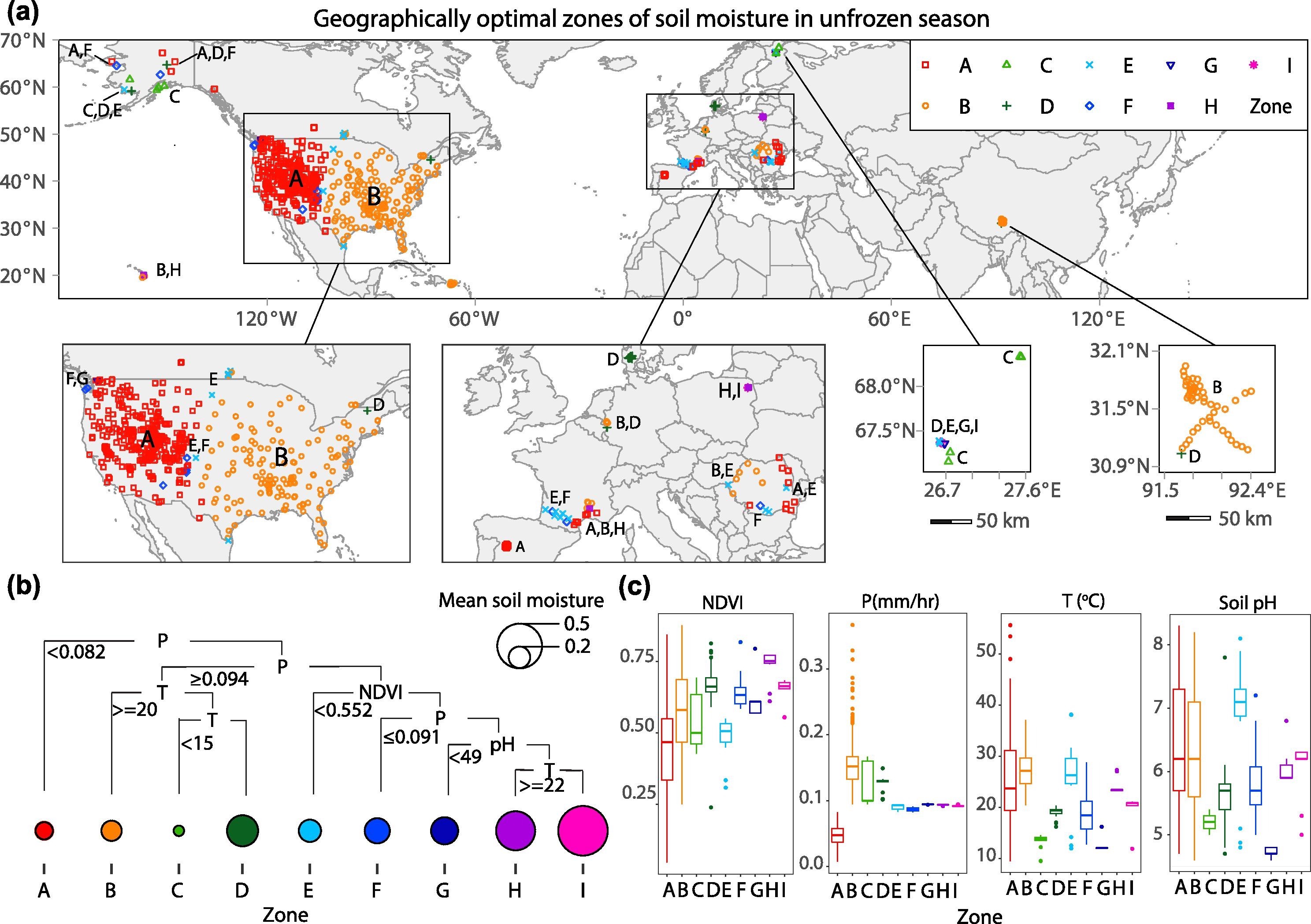
Soil moisture is a fundamental ecological component for climate and hydrological studies. However, the distribution patterns of soil moisture are spatially heterogenous and influenced by multiple environmental factors. The knowledge is still limited in assessing the large-scale spatial heterogeneity of soil moisture in in situ data modelling, in situ network design, spatial down-scaling, and remote sensing-based soil moisture retrieval. Heterogeneity models are effective in characterizing spatial disparities, but they are not capable of examining the maximum regional disparities. To address this bottleneck, the authors of this study developed a geographically optimal zones-based heterogeneity (GOZH) model. By progressively optimizing geographical zones of soil moisture and quantifying the heterogeneity among zones, GOZH may help identify individual and interactive determinants of soil moisture across a large study area. It was applied to identify spatial determinants of in situ soil moisture data collected at 653 monitoring stations in the Northern Hemisphere in unfrozen and frozen seasons from April 2015 to December 2017, with only thawed data considered in both seasons. Correspondingly, a series of variables were derived from Google Earth Engine (GEE) remote sensing data. The results demonstrated the significant regional disparities of soil moisture, and the combinations of determinants are critically different among geographical zones and between unfrozen and frozen seasons. At a global scale, the combinations of determinants can explain about 48% of the spatial pattern of soil moisture. Spatial heterogeneity of soil moisture in frozen seasons is much more complex than that in unfrozen seasons regarding geographical zones and explanatory variables. The variability of soil moisture during unfrozen seasons can be more explainable than that during frozen seasons, which was a convincing evidence for previous studies that soil moisture predictions were mostly performed during unfrozen seasons. Primary variables that determine spatial patterns of soil moisture are changed from climate variables during the unfrozen season to geographical variables during the frozen season. Results show that GOZH model can effectively explore spatial determinants of soil moisture through avoiding the underestimation of individual variables, overestimation of multiple variables, and finely divide zones. The research findings from this study provide an in-depth understanding of the spatial heterogeneity of soil moisture and can be implemented in more effective in situ sampling network design, spatial down-scaling of soil moisture, and accurate inversion of surface parameters from the satellite data of soil moisture.


